Sunday, November 5, 2017

The Hike to the Belmont Mine, History and a View

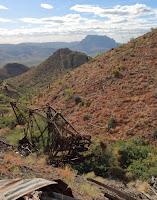
The Belmont Headframe
Directions: From Phoenix take the US 60 to Highway 177 South in Superior. Drive .9 miles to Apache Leap Rd. Travel 1.2 miles to what's left of an old mining road through Belmont Canyon. Stay on this trail and avoid any spurs to the left until you see the Grand Pacific Mine. The trail switch backs left just before the Grand Pacific.

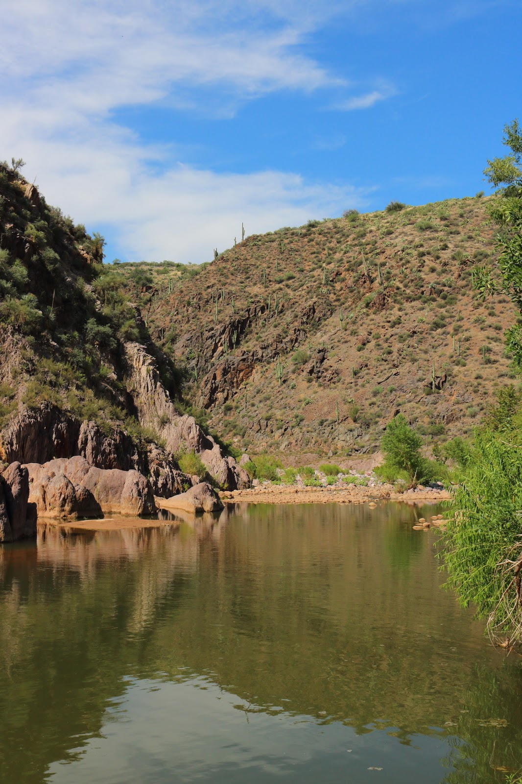
Dog Friendly: So-so, there isn't any water most of year so pack enough for you and your pooch. This is not a summer time hike, Fall through early Spring. There is cactus through most of the hike but the teddy bear or jumping cholla disappear as you gain elevation. Just beware and make sure you have a cone and some needle nose pliers. I did not come across any open shafts on this hike but we stayed on the road.

If you're looking for a short, challenging hike with the opportunity to visit history, this is the hike for
The Belmont Shaft
you. The trail head is just outside of Superior, along Apache Leap Road. The hike is only around three miles round trip but you're gaining over 1,000 feet of elevation. Plus if you take some time to explore the areas around the Grand Pacific and Belmont Mines, it will add some more time to your trip. The trail is actually an old mine road but I think it's been deliberately destroyed to make it more difficult to get to the mines. It's weathered into a very rocky, rough single track.

The Belmont Mine is tucked into Belmont Canyon under the looming cliffs of the Apache Leap. Copper, gold, silver and host of other minerals have been dug out of the ground at the Belmont Mine. The area was first prospected in 1899 and mining began in 1913 through about 1945.

Ronin in the hoist house.
The site has two buildings still standing and the Belmont Shaft, that is caged for our safety. I had the dogs with me and for once I was grateful for the protection. The shaft is 1,600 ft deep, I leaned over the cage to look down and it appeared bottomless. When I dropped some rocks down it, I could hear them hit the sides but never heard the definitive thud when they hit the bottom. Besides the shaft there are supposed to be over 30,000 feet of underground workings. One of the surviving buildings is the hoist house that still has some of the machinery inside. You can smell the grease. The other building might have been a workshop and there were some rock walls as well that may have been another building. There were also two rusty water tanks. This is one of the few abandoned mines I've come across where the head frame is still there but unfortunately it's now at the foot of the tailings pile in Belmont Canyon. It would have been cool if they had left it standing.

The view along the hike is tremendous. You look west towards Picket Post Mountain, Superior and the Superstition Mountains. You look east upwards at Apache Leap, named from the legend of when 45 Apache Warrior cornered by cavalry troops chose to leap to their deaths rather than surrender. This legend is part of the argument against the Resolution Copper Mine at Oak Flat. An interesting side note is that when I took the surface tour of the Oak Flat Mine site, the guide who is a member of the San Carlos Reservation disputed the legend.
The Belmont Mine

Monday, October 30, 2017

The Rugged Trail to the Grand Pacific Mine

Direction: It's only a short distance from Superior off of Apache Leap Road. The Google Map coordinates are: (33.269810,-111.070980). The road or trail is hard to see from the road, there is a ditch and mounds of rock. The road is rugged and is now only a single track trail but it's easy to follow.

Dog Friendly: So-so, there are cactus and there is no water. I didn't come across any open shafts but there is lot of mining in the area.

The Grand Pacific Mine claim was first discovered in 1900 and mined in 1916. The last year of production was 1955. Copper was the primary commodity, although they also mined silver, gold and manganese. I found a lot of tailings, a few foundations and a gated adit (see photo). There is also a lot of abandoned ore cart tracks.


I decided to make this another hike-a-bike adventure to save time on the descent but it was rugged trail. I was able to ride alot of the down and I was pretty cautious since I was alone. If you go by bike or hike, look out for the cat claw and other thorny bushes. Overall it was a good adventure, the mine was pretty cool and views were great.

Sunday, October 1, 2017

MTB Journey to the Bronx...Mine

Directions: The Bronx Mine is only a mile or so off the US 60 but its not easy to get there. The old mine road is blocked by a ditch and rocks. There isn't good area to park near the road. I ended up parking on the other side of the 60 and riding my bike to the road. There is an old gate that you can get through to get to the road. The Google Map coordinates for the road 33.361712, -110.975440. It's about 1.5 miles East of Top of the World.

Good for Dogs: Not so much, with out better parking and access. I can't see walking my pack along the 60.
Molybdenite...I think

The Bronx Mine was worked in 1942 as a Molybdenite, Silver, Gold and Lead mine. The property was originally worked in 1890 for Gold, Silver and Copper. I found a collapsed adit and shaft that i believe is relatively deep. There are some interesting rocks in the tailings but the mine itself isn't all that amazing.

I wasn't expecting much from this mine but I was determined to get there. There are several roads that aren't accessible because of private land in Top of the World and that pisses me off. The terrain in that area is fascinating. The old mine road to the Bronx mine was a great downhill and there appear to miles more in the area. I got off to a late start and by the time I explored the mine is was getting dark. I will be back to explore the roads some more and other workings in the area. 
Collapsed Tunnel at the Bronx Mine

Wednesday, September 6, 2017

The Oxbow Mine

Directions: The Oxbow Mine is located off of Highway 87 near Payson, from the Bush Highway, take Highway 87, 46.5 miles to Forest Road 537. Stay on this road for two miles, where you come to the mine road on your left. The Oxbow mine is about .5 miles.

This was quick and easy trip to the Oxbow Mine, which was a gold, copper and silver (plus a boat load of other minerals.) Gold was discovered here in 1875 and the area was mined from 1916 to the 1980s. There was a main tunnel that was over 500 feet long with shafts and other workings. Besides the underground mine this was also a placer mine. This area shows extensive mineralization. All in all a good trip to some interesting Arizona history.

Monday, September 4, 2017

Tonto Creek and the Pittsburgh Tonto Mine

Directions: From the Mesa take Highway 87 to Highway 188. Stay on Highway 188 for 3.3 miles and your going to turn left on Forest Road 649 for .5 miles where you will turn right on Forest Road 184. This road is rough and would require a high clearance 4WD. I parked here and hiked because I wanted a good hike for the dogs and I'm not that confident in my off roading skills. The coordinates for the mine (34°00'01.3"N 111°17'43.5"W)

Dog Friendly: Yes, I went in August and Tonto Creek was flowing and there were large swimming areas. This would be an ideal hike for late fall, winter and early spring. We left early and it was hot on the trip back (95 degrees when we got back to the truck). There are two significant uphills so make sure you're packing enough water for the climb out of Tonto Creek. Know yourself and your dogs, heat kills. Also there are cows, so if your dogs like to chase them, probably want to keep them leashed.

The hike to Tonto Creek wasn't the most exciting terrain but the creek itself and the canyon it flows
Howlie and Ronin standing guard at a prospect
through was great. There were several large pools deep enough for the dogs to have to swim. I kept my boots dry until we came to a point where I had to wade through waist deep water to keep going to the mine. In August the water was great, I'd imagine it would be a little chilly in December.

Adit partially filled with sand
The Pittsburgh Tonto Mine was a gold mine established in 1942. It wasn't right on the creek but up on the steep side of the canyon; however, it was easy to spot because there was a cable running from other side of the creek to the mine. I don't know for sure if it was part of the original mine as way to get the ore to the other side of Tonto Creek. I climbed up to an adit that was partially full of sand. The surrounding rock was highly mineralized and colorful. I did not make it up to the other workings. The canyon walls were steep but did not require climbing gear. I was going to keep going but Ronin didn't like being left and came up with me. I knew getting down was going to be hard enough without a 110 pound ridgeback scrambling around with me. I am definitely coming back when it cools off, without the dogs.


Tuesday, August 22, 2017

Exploring Copper Butte On a Mountain Bike

Heed This Warning!!
Directions: Copper Butte is located off of Battle Axe Road which is 12 miles South of US 60 on Highway 177. You're going to stay on Battle Axe until you reach a locked gate. Becareful, at about 1.9 miles you'll come to a fork, stay to the right for Copper Butte. The other road takes you to the White Canyon Wilderness, which is pretty cool as well.

Dog Friendly: Nah, wouldn't take my dogs here. No water unless it rains and the pits fill up.

Copper Butte is the location for the Copper Butte Mine (clever name), which is a copper mine, duh. They also mined silica and small amounts of gold and silver. The area was discovered in the early 1900s and was mine until the 1970s by various companies. At one point there was a 400 foot inclined shaft and a 114 foot vertical shaft that led to a 700 foot tunnel. There were also several pits of various sizes. When I went this weekend I found what may have been an inclined shaft with debris pushed up against the opening. I climbed to the top of the debris and could see into the opening. I couldn't tell how deep it was and based on the condition of the opening of the mine I wouldn't go into the mine. If you go don't be fooled by what looks like some interesting adits from a distance both are extremely shallow.
Both of these looked enticing from afar but we're shallow.

The surrounding area is amazing. I had wanted to explore Copper Butte since I went to explore some small canyon's near Battle Axe Butte. The views from Hwy 177 are great and they're even better from Copper Butte. It's rugged and beautiful place but it's the desert. It was cool for August when I arrived but it was still hot as hell. I never would have brought the dogs. I was little worried about myself and I'm pretty used to the heat. There was definitely more to explore but saw most of the main mine workings. I don't know if I'll come back to Copper Butte, if I do it will be in December. I am going to come back to explore the White Canyon Wilderness.
Battle Axe Butte viewed from Copper Butte

I brought my bike because I knew about the locked gate. I've used my bike for exploration before because I lift it over fences. Plus for Reymert and Bellevue it was great because there was a lot of climbing and even though there were times when I had to push it uphill, it more than made up for on the way down. Copper Butte was a practical MTB ride but not a great ride by any means.

Saturday, August 12, 2017

No Sleep til...Brooklyn Basin

Directions: I'm not going to give exact directions. Brooklyn Basin Mine and Ghost Town are several miles off of Bloody Basin Road in the Aqua Fria National Monument. This drive does require a 4wd and it was the first time that I would have been stuck without one. I was able to drive to within 1 mile of the mine but didn't trust the road at that point. I probably could have made it further but the road was severely eroded in places. This area was affected by the Goodwin Fire and the roads will be affected.

Brooklyn Basin was established as a town in 1907. There was a main building that served as boarding house for the miners that worked at the mine as well as several smaller buildings and residences. The walls for the boarding house is still there, as well as a chimney from a house. The chimney was made from rocks from the mine, you can see copper in some of quartz in the rocks. The house was reportedly made from wood and when it was purchased after the mine was abandoned, it was torn down and the lumber used in another nearby town. There are more rusty cans than I've seen at any other site, they're everywhere, in the town and near the mine. I think part of it might be the fire clearing all the brush.

The Brooklyn Basin Mine was a copper, gold and silver mine. There was some belief that it was going to be one of the most productive copper mines in the world, this didn't pan out and the mine was eventually closed. I found two shafts but neither of the them were very deep. I read that the main shaft was 400 feet and the tailings pile makes that seem likely. It's possible that it collapsed or was capped and back filled at some point, although it's still 50 feet deep or so.


In addition to the mine and town, there are remnants of an Native American Pueblo. Pueblos were built from rock and mortar but the only thing left at this point are piles of rock. There are ruins in the area that can be accessed from Bloody Basin Road.

Wednesday, July 26, 2017

Four Peaks (Brown's Trail)


Directions: Take Highway 87 to Four Peaks Rd which is about 4.5 miles from Bush Highway. Keep on this road until you reach you reach Pigeon Springs Rd on your right. You will stay on this until the road ends at the trail head.

Dog Friendly: So-so but know your dog and know the weather. I didn't take mine because even though it was in the upper 70s, I knew this would be a tough hike for me and didn't want to pack that much water. These are popular trails and I'd keep them leashed. Besides other trail users, this is a rugged wilderness with predators that would love an easy snack.

The Peaks shrouded in clouds
This isn't really the type trail I'd normally include in by blog but it's an Arizona Icon. I have so may shots of the Goldfields or Superstitions with this mountain looming in the background. I've been up there a couple of times but only had one really short hike. It's an awesome place with plenty or trails and the views are stellar. On Brown's Trail you get alternating views of the Valley and Roosevelt Lake to the Sierra Anchas. It's all single trek through a variety of vegetation. The area suffered a wild fire a few years ago but there are still some of the original pines in some areas. At the end of the trail it becomes more difficult and you have to scramble over some rocks if you want to keep going.

If this trail doesn't interest you or don't really like hiking it's worth the drive. A two wheel drive with decent clearance can make it up from highway 87. If you want an easier road but a longer drive, take Highway 188 to El Oso Rd on the East side of Four Peaks.

The view looking toward the Valley

Thursday, July 20, 2017

Richmond Basin, Another Arizona Ghost Town

Directions: From Mesa we traveled US 60 into Globe to turn North on Highway 188.  From there you're going to turn on Wheatfields Rd after about 4.5 miles. After another 1.8 miles turn right on North Hicks Rd. Travel about 2.4 miles and make a left hand turn onto FR 219. This traverses private property but the owner is allowing access at this time. There's some sign in scrapes of paper at the gate. After approximately 1.8 miles make a right onto Richmond Basin Rd which is FR220. You'll hit the ruins and mine after about 6.5 miles.

Dog Friendly: Normally I would never suggest taking dogs around mines but this area was fairly safe. I would still keep them leashed. There maybe water in the winter and spring but there was no water in July.

Richmond Basin was a small town established in 1890 to support the silver mine. I've seen information that the mine and town we're active until as late as 1930, there are many shafts in the area and based on tailings this was an extensively mined area. That said, this is an area where history has been almost completely sanitized for the sake of public safety.

Thank Goodness all the shafts had cages on them!
I worked for the Arizona State Mine Inspector as college intern in an abandoned mine safety program. I understand the danger that mines pose to the public but it's still sad to see the structures and mine workings that are a century old completely eliminated or barred off with doors, caps, foam, etc. Richmond Basin was made safe by placing futuristic space "cages" over the top of the mine opening. I've never seen anything like it. All the head frames are gone and really all that's left is the pile of debris from one of the old house, some rock walls and foundations.

Looking down in one of the shafts
Overall this trip was a major disappointment. Richmond Basin is almost an invisible ghost town but the landscape made the trip worthwhile, kind of.  There were some stellar views of Roosevelt Lake, Four Peaks and Globe-Miami. The FR 220 was in really good shape and a high clearance vehicle could probably make it. FR 219 is in wash and depending on the weather a 2wd could have trouble in deep sand or gravel. FR 220 is very narrow and really exposed in places, so if you have a fear of heights...don't look over the edge.


Tuesday, July 4, 2017

Magma Mine Building

I've been on Highway 60 through Queen Creek Canyon more times than I can count since I was kid. It's always been a fascinating place with the steep rock walls, hoodoos and remnants of the one of the most productive mining areas in the country. One thing in particular always caught my eye, high on top of a ridge right before the Queen Creek Tunnel. It was just an old metal building with what looked like an old head frame next to it. Still, for years I wondered what that building held and what the view was like from up there. The climb looked steep but no more steep than what I usually hike. I think part of it was I knew I'd hike up there and it would be an empty warehouse filled with graffiti and junk.

Yesterday, I got out of work early and decided it was day to get up that ridge. The hike up was easier than I expected, there was an old, weathered road that led to the top. The building itself was bigger than looked from below and it was not disappointing. Far from empty, it was filled with machinery from the mining boom that ran from the late 1800s to 1890. This building housed motors for either the aerial tram or the hoist house for Magma Mine. The machinery was excellent condition and the smell of grease permeated air. The structure that looked like a head frame was part of the tram or hoist system. It was impressive.

The road kept going to the west side of the ridge to another old building that may have been a transformer house and excellent views of the rest of the Magma Mine workings, such as the cooling tower and smelter. This property is now part of the Resolution Copper Mine.

Note: I did not give exact directions for this hike because there are dangers to being around mines and abandoned buildings. I also know this blog is for hikes that are dog friendly (this one is not) or mountain biking but I also have interest in Arizona mining history and the Superior/Oak Flat Area. I admire the hard work and ingenuity of the early miners. I still hate to think about losing Oak Flat to another copper mine.


Tuesday, May 30, 2017

Reymert Ghost Town

Processing Kilns at Reymart
Directions: I'm not going to provide the directions I used to get to Reymert. Try the route in Google Maps, which will have you take the US 60 to N. Mineral Mountain Rd and then to N. Reymert Rd.

Dog Friendly: Not in the summer. There's a lot cactus and off road vehicles that use these roads.

Reymert is another mining town in the Superior area. All that's left is a few foundations and a couple of processing kilns. I road my mountain bike and as usual bit off more than I should have. I left in the late afternoon to avoid the heat and ended up making a brutal climb in the dark. The country is rugged and steep. Reymert Rd is located in a wash. Since I came in from the East, I'm not sure how the road is coming in from Mineral Mountain Rd from the west. I don't think there are many people who have ridden a bike to this ghost town.

It was still a good adventure and always interesting to see some Arizona history. Reymert was founded in 1890 to support the Reymert Silver Mine.


Thursday, May 11, 2017

Richinbar Mine and Ghost Town

Directions: The hike to this mine on the North Bound Lane of I17 just past the Sunset Point rest area. The coordinates from Google maps are (34.206753, -112.119748). There is a locked gate and with for parking. You will need to either climb the gate or squeeze through it. Follow the road past the wind mill and the cattle coral. You should see the FR 9006 marker. This will take you to the canyon and you can see some of the foundations. Follow the road along the canyon to the right and that will lead you to the mine workings.

Dog Friendly: Nope. There are some extremely deep mine shafts that aren't fenced and cattle.

Old Foundation at Richinbar
This is an area that you drive through on your way to Sedona, Prescott or Flagstaff as I've done for years. I knew there was a lot of mining on the other side of the I17 in the Bradshaws but I had never heard of the Richinbar Mine. I was looking for quick trip that my son and I could take on the way to Flagstaff and found this little historical gem.


This blog is mostly about places I take my dogs hiking or I go mountain biking but I'm also intrigued by old mines. In college I had an internship with Arizona State Mine Inspector locating and researching abandoned mines. It was a great summer jobs as I got paid to go to some remote and rugged locations around the state. I was always amazed at how the first explorers made their way to those places without roads and occasionally found their fortunes.

The Zyke Shaft
The Richinbar mine was founded in the1890s and worked until approximately 1948. They mined over 4600 Troy ounces of gold and another 1400 Troy ounces of silver. The mine also produced copper and lead. There are several shafts in the area, the deepest one being the Zyke shaft which was over 500 feet deep. This is a dangerous mine as some of the shaft are poorly fenced or not fenced at all. If you come here to explore be mindful where you step.


There are foundations for many buildings as well as a 20 stamp mill but thats pretty much all that remains. There are some very unique structures that I read may have been cyanide tanks but we thought maybe they were some type of kiln or oven. There's also a tank that looks like an old swimming pool on top of one of the hills. There are a lot of old bricks, cans and some broken bottles though out the site.
Storage, oven or a tank?
 Beyond the mine and the ruins, there are some fantastic views of the Aqua Fria Canyon. I've also read there are petroglyphs in the area. I would consider coming back to hike down into the canyon and check out the petroglyphs.

Sunday, April 23, 2017

Oak Flat Mine Rd

Directions: Take US 60 towards Globe. The turn is at Mile Post 231, where you turn left onto a dirt road. Magma Mine Rd which takes you to the Oak Flat campground is the right had turn at this intersection. You want to stay on this main road as it turns left for a .5 miles until you come to a locked. This is where you park. The road should be easy enough for most cars.

Dog Friendly: Yes, minimal cactus. There was still water in the creek but it will probably be gone soon.

This one of my favorite hikes that is strictly for the dogs. It was 97 degrees when I left Mesa and when we got to the gate it was 83 degrees. It takes a little over 30 minutes to get there from the 202 and the 60. The whole hike is on an old mine road, so it's easy to follow and it's a gradual uphill that's almost unnoticeable.  The road follows a creek which is still barely running but was lot of fun all spring. We went in the afternoon so the route was shaded by the surrounding hills. The road leads to an old open pit copper mine. Watch out for cattle.