 |
| The Belmont Headframe |
Directions: From Phoenix take the US 60 to Highway 177 South in Superior. Drive .9 miles to Apache Leap Rd. Travel 1.2 miles to what's left of an old mining road through Belmont Canyon. Stay on this trail and avoid any spurs to the left until you see the Grand Pacific Mine. The trail switch backs left just before the Grand Pacific.
Dog Friendly: So-so, there isn't any water most of year so pack enough for you and your pooch. This is not a summer time hike, Fall through early Spring. There is cactus through most of the hike but the teddy bear or jumping cholla disappear as you gain elevation. Just beware and make sure you have a cone and some needle nose pliers. I did not come across any open shafts on this hike but we stayed on the road.
If you're looking for a short, challenging hike with the opportunity to visit history, this is the hike for
 |
| The Belmont Shaft |
you. The trail head is just outside of Superior, along Apache Leap Road. The hike is only around three miles round trip but you're gaining over 1,000 feet of elevation. Plus if you take some time to explore the areas around the Grand Pacific and Belmont Mines, it will add some more time to your trip. The trail is actually an old mine road but I think it's been deliberately destroyed to make it more difficult to get to the mines. It's weathered into a very rocky, rough single track.
The Belmont Mine is tucked into Belmont Canyon under the looming cliffs of the Apache Leap. Copper, gold, silver and host of other minerals have been dug out of the ground at the Belmont Mine. The area was first prospected in 1899 and mining began in 1913 through about 1945.
 |
| Ronin in the hoist house. |
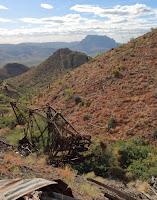
The site has two buildings still standing and the Belmont Shaft, that is caged for our safety. I had the dogs with me and for once I was grateful for the protection. The shaft is 1,600 ft deep, I leaned over the cage to look down and it appeared bottomless. When I dropped some rocks down it, I could hear them hit the sides but never heard the definitive thud when they hit the bottom. Besides the shaft there are supposed to be over 30,000 feet of underground workings. One of the surviving buildings is the hoist house that still has some of the machinery inside. You can smell the grease. The other building might have been a workshop and there were some rock walls as well that may have been another building. There were also two rusty water tanks. This is one of the few abandoned mines I've come across where the head frame is still there but unfortunately it's now at the foot of the tailings pile in Belmont Canyon. It would have been cool if they had left it standing.
The view along the hike is tremendous. You look west towards Picket Post Mountain, Superior and the Superstition Mountains. You look east upwards at Apache Leap, named from the legend of when 45 Apache Warrior cornered by cavalry troops chose to leap to their deaths rather than surrender. This legend is part of the argument against the Resolution Copper Mine at Oak Flat. An interesting side note is that when I took the surface tour of the Oak Flat Mine site, the guide who is a member of the San Carlos Reservation disputed the legend.
 |
| The Belmont Mine |

 The Pine Strawberry trail is a good out and back ride that takes you from Pine to Strawberry on some nice forest, single track. There are some good climbs and descents, with a few rocky patches but the whole ride is doable, depending on your fitness level. The elevation tops out at 6,028 ft and has a low point of 5,689 ft. The trail offers some great views of Pine, Strawberry and beyond.


